Minds On
Exploring landforms
Explore the following images and descriptions of a variety of landforms. Take note of the physical characteristics of each landform and what makes each one unique.
Press ‘Definition’ to access more information about physical characteristics.
Record your notes orally, digitally, in print, or in a method of your choice. Be ready to use your notes to be able to match the landform to its characteristics in the Action section of this lesson.
Press the ‘Activity’ button to access the Landforms Notes document. You may use the document or your notebook.

China’s Huangshan Mountains
These mountains are made of rock with vegetation growth, which is not always typical of mountains.

Plains of Saskatchewan
The image shows a flat expanse of land covered in wild growing plants and flowers.
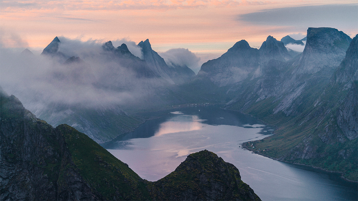
A Valley in Norway
The valley is the lower area of land between two mountains. As in this case, valleys often have streams running through them.
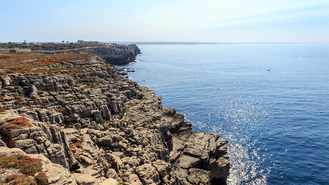
Portugal’s Plateau
This image of a plateau overlooking the sea in Algarve, Portugal shows a flat, rocky landscape that is high above other landforms surrounding it. It has steep sides but at the top it is flat.
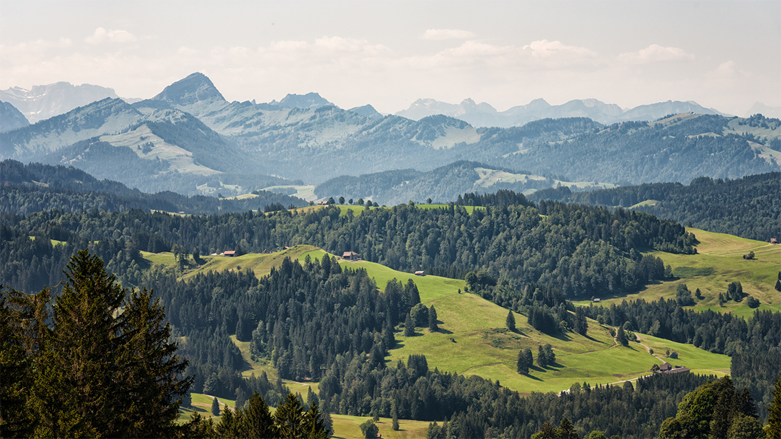
A Hillside in Switzerland
This image of a hillside in Switzerland shows a series of trees on sloping hills, covered in grass. The hills are gentle slopes that are higher than the surrounding land but not as high or steep as a set of mountains that are shown off in the distance.
Action
Part 1: Landforms matching activity
Use your notes from the Minds On images and descriptions to match the landforms of mountains, valleys, hills, plateaus, and plains to their definitions. The definitions can be found on the World Landforms website, where you can learn more information about landforms and ways to protect landforms around the world.
Press ‘What is a Landform’ to access a definition of a landform.
Source: http://worldlandforms.com/
Part 2: What more can I learn about landforms?
It is time to learn a little more about these landforms. The following checklist contains questions about the five landforms. Choose three of the landforms to investigate a little further!
If possible, conduct an online search of geographic websites to help answer the questions, such as Canadian geographic websites, world geographic websites or national parks websites.
You can also use the physical descriptions shared in the Minds On activity to assist you. You can use the activity provided to record your answers or use a method of your choice.
Learning about landforms
Complete the Landform Notes in your notebook or use the following fillable and printable document.
Press the ‘Activity’ button to access Landform Notes.

Brainstorm
Review questions
Complete one of the questions:
- Of the three landforms that you investigated, which one did you find to be the most interesting? Why?
- What question did you find provided the most interesting information about this landform? Why?
Part 3: Landforms on a relief map
What is a relief map?
Press ‘Relief Map’ to access the answer to this question.
A relief map represents how elevation is varied in different areas of the Earth, from deep in the ocean to high in the mountains.
Elevation is displayed by different colours and shades of colour.
What is sea level and why is it important?

Press ‘Sea Level’ to access the answer to this question.
In a relief map, there is a change in the darkness and lightness of colour based on the elevation of the land and water.
Here are some guidelines for helping to understand a relief map:
- The title of a relief map will guide you as to the locations of the world that are highlighted.
- There will be a scale that will provide a colour code for the actual elevation in metres. It also provides numbers for the elevation at various points along the scale (positive numbers for above sea level and negative numbers for below sea level).
- The land and water will differ in the shade of the colour depending on its elevation.

This map of the world shows the elevation of the land and water of the Earth. The depth of elevation is depicted with colour nuances and numbers (with negative numbers being below sea level and the positive numbers being above sea level). The negative numbers (-39,624, -914 and 197) are different nuances of blue (the larger negative number, the darker shade of blue), the number 0 is green and the positive numbers (488, 1006, 1372, 1981, 3048) move from light green, through yellow and orange, to red. Some patterns of elevation of the land shows that Antarctica and Greenland have higher than average elevation levels. Much of the water on the shores of the continents are closer to the sea level marker of zero. As you move away from the shore, the water elevation becomes further into the negative numbers. The higher elevation of land appears often closer to the shores than the lower levels of elevation. These lower levels of elevation tend to appear in the interior of the land mass, but there are some exceptions to these patterns.
Task 1: Representing landforms
Using this relief map, determine how the three landforms that you investigated would be represented.
You can record your responses in a method of your choice.
- How would each of your three landforms be represented on a relief map?
- What colour and/or elevation category number would your landforms be? Why?
Connections
Recognizing patterns
- What patterns do you notice about the levels of elevation of land masses around the world?
Press ‘Hint’ to access clues about patterns of elevated land masses.
- What patterns do you notice about the levels of elevation of water around the world?
Press ‘Hint’ to access clues about the levels of elevation of water.
- What is one question you have about these patterns?
Task 2: Types of mountains
Mountains are the landform with the highest elevations in the world. They can be found on every continent of the Earth and in the depths of our oceans as well.
Mountains are created over a VERY long time when the plates of the Earth move and shift.
Press ‘Definition’ to access more information about plates of the Earth.
There are five different types of mountains. Press on the following titles of each type of mountain to learn more about them.
These are the most common type of mountains on the Earth. They have been formed over millions of years when two plates hit each other head on, crumbling their edges.
Examples of fold mountains include: The Rocky Mountains in North America, the Alps in Switzerland and the Himalayas in South and East Asia
These occur when there are cracks formed in the Earth, which breaks the rock into chunks. As these pieces move, they stack on top of each other. They usually have a steep front and sloping back.
Examples of fault block mountains are the Sierra Nevada Mountains in North America and the Harz Mountains in Germany.
These occur when a lot of melted rock from under the Earth pushed its way onto the Earth’s surface. When the rock hardens, it forms the shape of a dome.
An example of dome mountains is the Adirondack Mountains in the United States.
These occur when magma from deep within the Earth erupts and creates a pile on top of the Earth. When it cools, it turns to rock, which piles on top of the lava.
Examples of volcanic mountains are Mount St. Helens in North America and Mount Pinatubo in the Philippines.
These mountains are formed by erosion. They are large flat areas that have been pushed above sea level through the force of the Earth. They are usually found near fold mountains.
Examples of plateau mountains are in Bogota, Colombia and the Tibetan Plateau in Tibet.
Task 3: The highest mountains
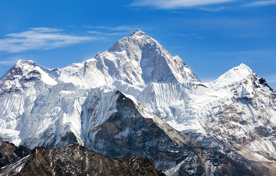
The following five mountains have the highest elevation in the world!
- The summit of Mount Everest, the highest point on Earth
- K2, the highest summit of the Karakoram
- Kangchenjunga, the second-highest mountain of the Himalayas
- Lhotse, the third-highest mountain of the Himalayas
- Makalu in the Himalayas
For each of these mountains, search for the following information using a geographic website such as a Canadian geographic website or world geographic website:
- What type of mountain is this?
- Where in the world is it located?
- What is one interesting fact about this mountain (besides its elevation)?
Record your findings in a method of your choice.
Consolidation
Option 1: Locating landforms
You will use a relief map of the world, digitally or in print, to locate two to three specific locations in the world where each of your three investigated landforms exist.
For each landform, use the following checklist to guide your location:
Locating landforms
Press ‘Hint’ to access clues about relief maps.
This map of the world shows the elevation of the land and water of the Earth. The depth of elevation is depicted with colour nuances and numbers (with negative numbers being below sea level and the positive numbers being above sea level). The negative numbers (-39,624, -914 and 197) are different nuances of blue (the larger negative number, the darker shade of blue), the number 0 is green and the positive numbers (488, 1006, 1372, 1981, 3048) move from light green, through yellow and orange, to red. Some patterns of elevation of the land shows that Antarctica and Greenland have higher than average elevation levels. Much of the water on the shores of the continents are closer to the sea level marker of zero. As you move away from the shore, the water elevation becomes further into the negative numbers. The higher elevation of land appears often closer to the shores than the lower levels of elevation. These lower levels of elevation tend to appear in the interior of the land mass, but there are some exceptions to these patterns.
Option 2: Create a model of your landform
You will create a 3-dimensional model of one of the three landforms that you investigated or one of the top five elevated mountains.
Use a real landform in a real location (e.g., Mount Everest or Saskatchewan Plains) as your inspiration.

Use the following checklist to guide your model creation
Creating model landforms
Reflection
As you read the following descriptions, select the one that best describes your current understanding of the learning in this activity. Press the corresponding button once you have made your choice.
I feel...
Now, expand on your ideas by recording your thoughts using a voice recorder, speech-to-text, or writing tool.
When you review your notes on this learning activity later, reflect on whether you would select a different description based on your further review of the material in this learning activity.
Discover MoreIn this learning activity, you explored data about elevation of land and water using a relief map of the world. Another type of map that analyses elevation levels of various locations is a topographic map.
Topographic maps work alongside relief maps in that they share the elevation of a particular area through lines, symbols, and colours.
Conduct a short search of elements of a topographic map, using Canadian and world geographic websites. You can type these questions directly into your search window.
- What do the lines represent on a topographic map?
- What do the colours represent on a topographic map?
- What information can you learn about a specific area based on these lines, colours, and symbols?
Explore this image of a topographic map.
- What do the lines represent?
- What do the colours represent?
- What information can you learn about this area based on these lines, colours, and symbols?
 Description
A topographic map of an aerial view of a landscape with a river running from the southeast to the northwest corners. The map has a legend along the base with five images and categories. The first category is represented by a thin line and is labelled ‘Contours showing a varied elevation of the land.’ Changing elevations on the map are outlined using the contour lines. The second category is represented by the colour blue, and is labelled ‘Areas of water (lakes, rivers, creeks, etc.).’ The river is outlined in the blue to represent an area of water. The third category is represented by a thick line and is labelled ‘Larger transportation routes (highways).’ Three highways are represented on the map with the thick line. The fourth category is represented by a medium line, and is labelled ‘Smaller transportation routes (sideroads, railways, trails, etc.).’ Several medium lines on the map represent smaller routes that are attached to the larger routes. The fifth category is represented by the colour purple and is labelled ‘Newly updated areas (not verified yet). There are a few small outlined areas that represent areas where accurate information is not known.
Explore the topography of an area of interest. You can do an internet search for this area or use a digital mapping tool to guide your search.
How much information do the simple lines, colours, and symbols share about this area?