Minds On
How much has Canada changed?
Analyse the two following maps and find the differences between Canada today and Canada in 1867.
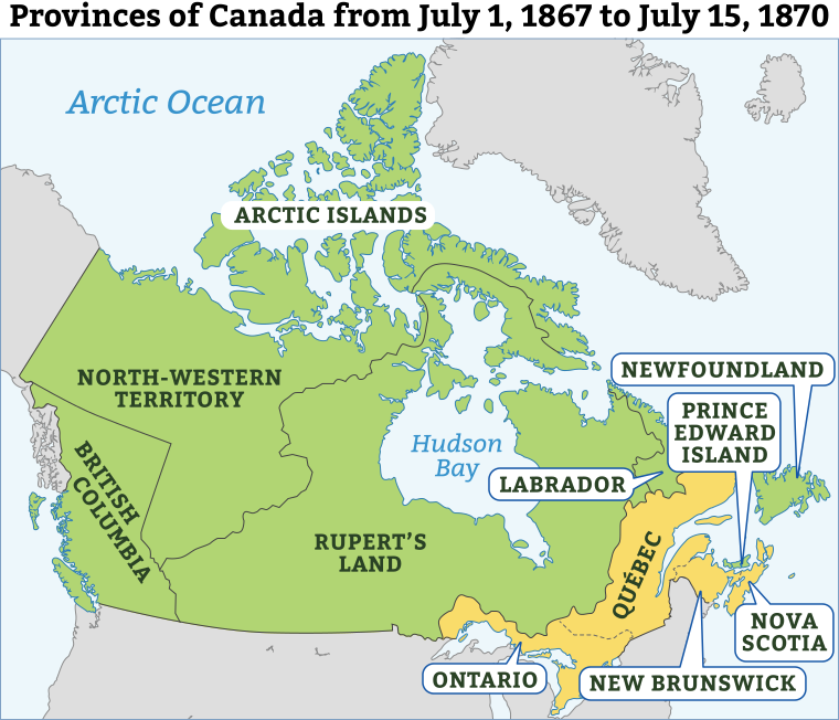
A historical map of Canada showing its provinces and territories as they existed from July 1, 1867, to July 15, 1870. British Columbia appears on the west coast, with the NorthWestern Territory and Rupert's Land covering most of central and northern Canada. The Arctic Islands are labeled in the far north. Hudson Bay is centered in the map, bordered by Labrador to the east. On the Atlantic coast, the labeled regions include Newfoundland, Prince Edward Island, Nova Scotia, New Brunswick, and Québec. Ontario is shown south of Hudson Bay.
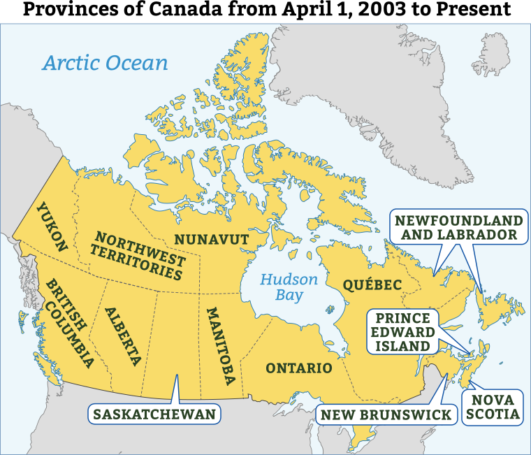
A map titled “Provinces of Canada from April 1, 2003 to Present” shows present-day Canada divided into its ten provinces and three territories. Forming the top of Canada are the three northern territories: Yukon in the northwest, Northwest Territories in the center, and Nunavut across the northeast. South of them are the western provinces: British Columbia on the Pacific coast, followed by Alberta, Saskatchewan, and Manitoba stretching eastward.
In the central and eastern regions, Ontario lies south of Hudson Bay with Québec to its east. Along the Atlantic coast are the Maritime provinces: New Brunswick and Nova Scotia on the mainland, and Prince Edward Island just off the coast. The easternmost province is Newfoundland and Labrador, with Labrador on the mainland and the island of Newfoundland to the southeast.

Brainstorm
What’s changed?
How has Canada changed since 1867 and how has Canada stayed the same?
Sort your findings into the following fillable and printable document Change and Continuity T-Chart. You may also record them in a method of your choice.
| Change | Continuity |
|---|---|
|
|
|
|
|
|
|
|
Action
The expansion of Canada
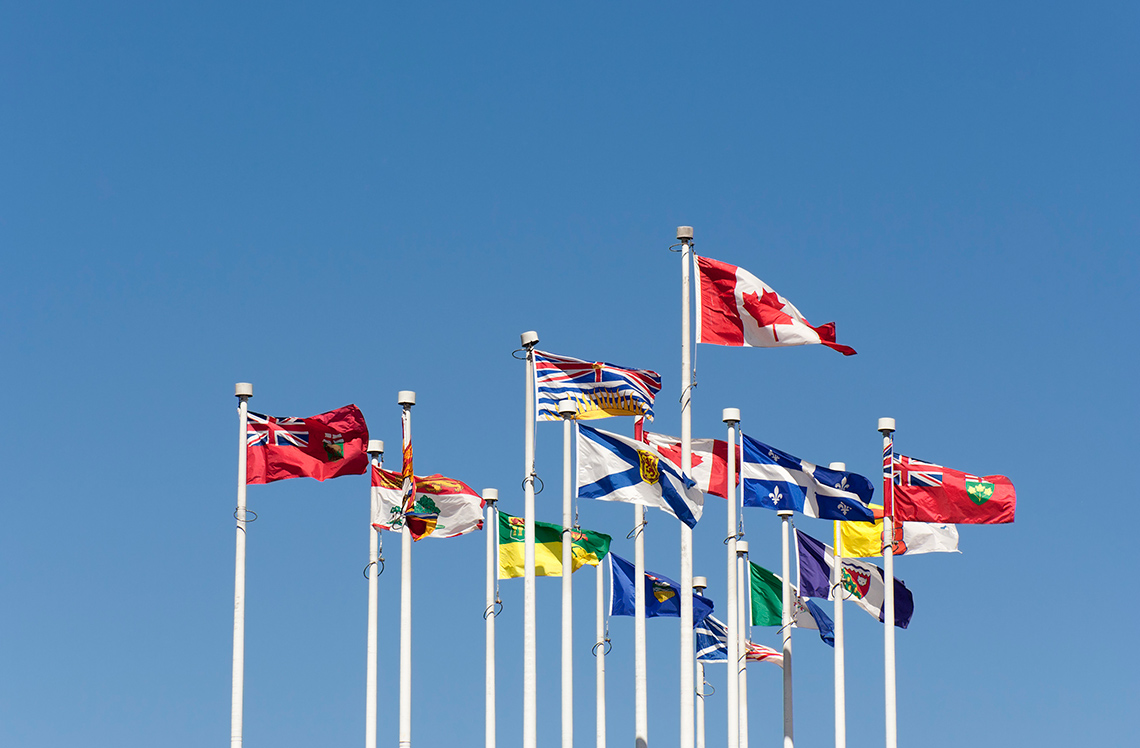
At the time of Confederation in 1867, the Dominion of Canada consisted of four provinces: Ontario, Quebec, New Brunswick, and Nova Scotia.
However, the federal government prioritized expanding the land mass of Canada over North America, and over the course of the next several decades, made efforts to acquire additional provinces and territories.
Reasons for settling the West
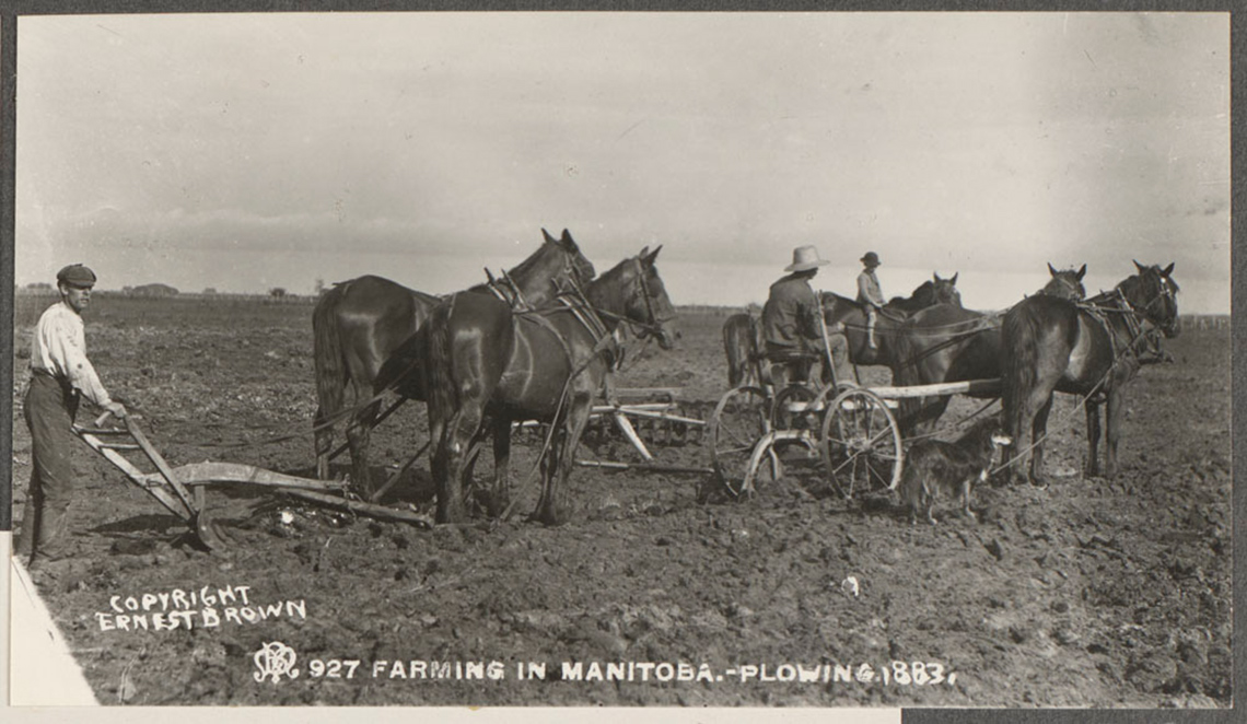
From 1867 to 1914, Western Canada was opened for mass farming and settlement and became home to millions of European immigrants seeking a new life. The rapid settlement of the West was vital to combat the growing expansion of the Americans who were expanding their land westward and southward. The Canadian government feared that there was a risk that the Americans would try to claim the land towards the North. The settlement of the land formerly held by the Hudson’s Bay Company would be one of the first concerns of the newly formed Dominion of Canada.
In the years following Confederation, the Prairie provinces of Manitoba, Saskatchewan, and Alberta grew rapidly as settlers began to farm the flat landscape. Many motivations brought European settlers to Canada: greater economic opportunity, an escape from oppression or prosecution, as well as opportunities and adventure. Sir Clifford Sifton, Minister of the Interior, promoted immigration from groups like the Ukrainians, Hungarians, and Mennonites as political and economic situations in Europe grew increasingly challenging during this period. As a result, the population of the West exploded. For example, the city of Winnipeg grew from a city of 20,000 in 1886 to 150,000 in 1911.
The expansion of Canada
In 1870, the Hudson’s Bay Company transferred Rupert’s Land to Canada. Canada wanted to expand westward, gain control of valuable land and natural resources, and prevent the United States from expanding northward into the region. This allowed Canada to extend its territory and strengthen its control over the West.
That same year, Canada continued to grow with the creation of Manitoba and the Northwest Territories. Manitoba was established in 1870 to bring the Red River region under Canadian authority and to support settlement. It was also created in response to resistance from the Métis population. These changes helped the government organize and govern the new western territories.
Also in 1870, the Northwest Territories were created from the remaining lands acquired from the Hudson’s Bay Company. By taking control of this large area, Canada could manage land use, encourage settlement, and access natural resources.
In 1871, British Columbia joined Confederation. This decision was influenced by the need for economic growth and better connections to the rest of the country. British Columbia agreed to join after Canada promised to build a transcontinental railway. This railway would link the province to eastern Canada, making trade, travel, and communication easier while also strengthening national unity and security.
Prince Edward Island joined Confederation in 1873. The island was facing financial challenges and saw joining Canada as a way to reduce its debt and gain support from the federal government. Confederation provided greater economic stability and helped strengthen cooperation between the province and the rest of the newly formed country.
Complete the Mapping Canada in 1873 Activity in your notebook or using the following fillable and printable document. You can also use another method of your choice.
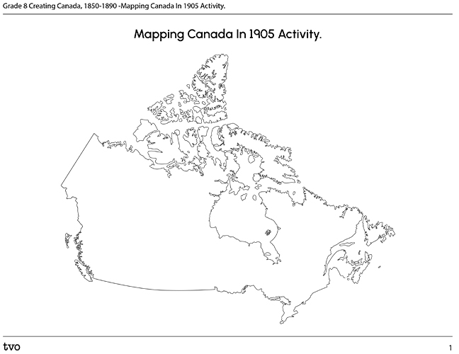
Press the Activity button to access the Mapping Canada In 1873 Activity.
Activity(Opens in a new tab)Timeline activity
Use the following timeline to help you correctly organize when each province and territory joined Canada.
The Homestead Act
The Canadian Homestead Act, or Dominion Lands Act, passed in 1872 and was in use until 1918. The purpose of the Act was to encourage European, American, and Eastern Canadian settlers to come and settle the Prairie provinces in Canada. The Homestead Act gave 160 acres for free to any male farmer if the following conditions were met:
- agree to farm or cultivate 40 acres of the land
- build a permanent dwelling within three years
- pay $10 for the registration fee
Farmers also had an opportunity to buy the neighbouring 160 acres for the same $10 and this allowed many farmers to double the size of their farms. Although this Act did not immediately create a mass migration into the Prairie provinces, it would help in settling the West and expanding Canada’s presence into the Prairie provinces. Overall, about 125 million hectares of land were given away by the government under The Canadian Homestead Act. That is about the size of 200 Prince Edward Islands.
Checking your understanding
Complete the following true/false activity.
Select either "true" or "false" for each of the following statements about The Homestead Act.
Reflect

Record your responses to the following questions in a method of your choice.
- What were the intended and unintended consequences of this Act?
- Whose voice or opinion is missing in the settlement of Western Canada and The Homestead Act? Why do you think this is?
Métis land scrips
The land scrip policy was used in some areas of Canada (for example, in parts of Western Canada) to extinguish Métis title and ownership to their traditional territories. To the Canadian government, the scrip process would help remove Métis families from their homelands to make room and provide better lands to European settlers.
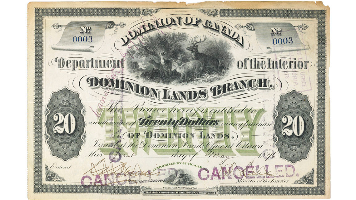
A scrip was a certificate that could be either exchanged for land (land scrip) or for money to buy land (money scrip). A scrip was used to transfer land to Métis Peoples in Canada from 1885 until the 1920s during the same period as Canada’s race to settle the West. Land scrips allotted either 160 or 240 acres to a Métis individual.
The land scrip process was extremely problematic for a number of reasons. Authorities could allocate new lands for a Métis person anywhere within the province. If a Métis person lived in southern Manitoba, there was no guarantee that the lands provided to them would even be relatively close by. Similarly, a scrip also had to be claimed at a Land Titles office. These offices could be hundreds of kilometres apart from each other. As a result, some Métis families never received their allotted land due to the sheer distance to travel to the offices or to the land itself. Some Métis families watched as Europeans settled on their lands before they were even given a scrip. Anger and frustration caused some to leave before even receiving their scrip and to travel further west to Alberta and Saskatchewan from Manitoba.
Land scrips illustrated the lack of recognition of Métis identities and rights in Canada. In other areas, the Métis Peoples went largely unaddressed by the governments of the time. Métis Peoples faced unjust policies. In Ontario, for example, numerous requests and petitions by Métis communities to create treaty agreements were ignored by the federal government, which is an issue that remains unresolved to this day.
Fill in the blank
For each sentence, select the missing word from the drop-down menu. Each sentence will focus on land scripts.
Consolidation
Create your own poster

Create your own poster that exposes the true history of settling the West and the truth behind the propaganda.
This might be an illustration of the true hardships that Europeans faced when they moved to Canada or how Indigenous Peoples were removed from their homelands to make room for more European settlement.
Consider including images and text if possible. You can create your poster using a medium of your choice.
Map analysis
Revisit the map you created earlier in this learning activity. The six years following Confederation were a period of rapid growth and expansion in Canada. Using your map, identify ways Canada changed and stayed the same between 1867 and 1873.
Sort your findings into the Change and Continuity T-Chart provided. You may also record your ideas using another method of your choice.

Pause and Reflect
Pause and reflect
Reflect on the following questions. You may wish to record your answers in your notebook or in a method of your choice.
- Based on how much Canada expanded between 1867 and 1873, what challenges would the federal government face in keeping the country connected?
- These maps show political borders drawn by the federal government. Whose land, territories, and voices are ignored or left out in this process?
- Canada’s landmass more than quadrupled in just six years. What economic, political, or social pressures might have led to such rapid expansion westward?
Reflection
As you read the following descriptions, select the one that best describes your current understanding of the learning in this activity. Press the corresponding button once you have made your choice.

I feel...
Now, expand on your ideas by recording your thoughts using a voice recorder, speech-to-text, or writing tool.
When you review your notes on this learning activity later, reflect on whether you would select a different description based on your further review of the material in this learning activity.
Press Discover More to extend your skills.
Discover MoreFirst Nation communities were also experiencing similar challenges during this time with the Numbered Treaties. Research the Numbered Treaties and use the following questions as a guide. Record your findings in a journal, orally using an audio recording, or any method of your choice.
- What similarities are there between the Numbered Treaties with First Nations and Métis land scrips?
- What seems to be the goal of the Canadian government in the creation of the Numbered Treaties and the land scrips?
- Why are the Métis included and then removed from Treaty 3? What impact does this have on the Métis today?