Minds On
Ontario and Quebec
Explore the following two maps of Ontario and Quebec.
The first map shows the borders of Ontario (then called Upper Canada) and Quebec (then called Lower Canada) in the late 1700s-mid 1800s.
The second map shows the borders of Ontario and Quebec now.

In the first map, Upper Canada (now Ontario) is only the south and southeast part of Ontario around the Great Lakes and the St. Lawrence River. Lower Canada (Quebec) is the south and east part of Quebec and also includes Labrador.

Based on the two maps, what do you notice about Ontario and Quebec that is different in the past than it is today?
Press ‘Hint’ to reveal what is different about Ontario and Quebec today.
Action
First Nations and Métis communities
In 1780-1850, in Upper and Lower Canada, many First Nations and Métis Communities were thriving on the land. At this time, some First Nations Communities and the British government signed formal agreements, called treaties. With these signed agreements many British settlers came to the land we now call Canada to begin a new life.
Press ‘Definition’ to access the definition of treaties.

First Nations communities
As more settlers continued to arrive, they demanded more area for themselves. The First Nation communities who were already here were forced to leave their homes because of the treaties with the British Crown. They were placed in areas that were outside of the areas the Crown (government) wanted for the new settlers. This meant they not only lost access to their homes, but also their traditional lands that they hunted, fished, and grew crops on.
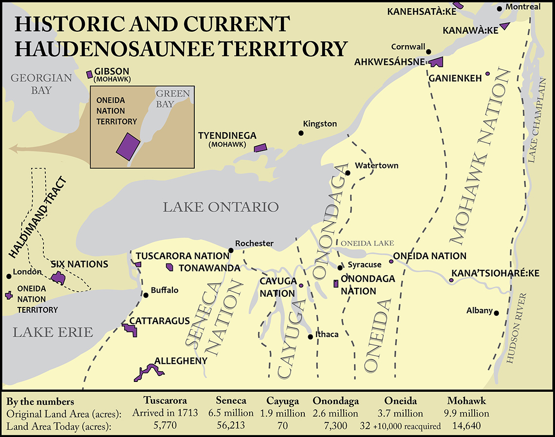
The Six Nations of the Haudenosaunee was one Nation (they are a confederacy) that was moved for the new settlers. The following map shows where the Six Nations of the Haudenosaunee were relocated by the British Crown. The Tyendinaga Mohawk First Nation is the reservation in the Bay of Quinte.
The historic territory of the Six Nations is the large area between the lines where the Nations’ names are written.
Before the British arrived, the territory of the Haudensaunee extended across what we now call Canada and the United States in the Great Lakes area.
The shapes that appear in purple with all capital letters are the current territory of the Haudenosaunee.
 Description
This map shows where the Six Nations of the Haudenosaunee were relocated to by the British Crown.
The Six Nations displayed on the map are: Tuscarora, Seneca, Cayuga, Onondaga, Oneida, and Mohawk.
There are 10 areas noted on the map that are the current territory of the Haudenosaunee. They are Gibson, Tyendinega, Ahkwesahsne, Kanehsatake, Kanawake, Ganienkeh, Allegheny, Cattaragus, Tonawanda, and Kanatsiohareke.
During a battle between the British and the Americans in the late 1700s, some members of the Six Nations fought alongside the British colonies, and some fought alongside the Americans.
Those who fought alongside the British were provided land in Canada to live on. Those who fought alongside the Americans were given land in the United States.
Frederick Haldimand, a governor in Chief of Quebec bought land from the Six Nations around the Great Lakes, then gave permission for this Nation to live in an area called Bay of Quinte that was reserved for them. They also reserved land for Anishinaabeg Nations in Manitoulin Island in Upper Canada.
Source: Haldimand, F. (n.d.). The Haldiman Treaty of 1784. Six Nations lands and resources. https://www.sixnations.ca/LandsResources/HaldProc.htm
After you have explored the map of the Six Nations of the Haudenosaunee Confederacy, answer the following questions about the map.
Brainstorm
Share your thoughts
Why do you think the British Crown relocated most of these Nations further away from the Great Lakes and St. Lawrence River?
Press ‘Answer’ to reveal why the British Crown relocated these Nations away from the Great Lakes.
Métis communities in Upper Canada
Métis communities began to grow around the areas where fur trading posts were located around the Red River in Manitoba and northern regions of the prairie provinces. These communities were made up of those who were children and grandchildren of relationships between First Nations peoples who were usually Cree, Saulteaux or Dene and settlers who formed their own historical Métis nation communities.
Métis communities developed a unique and distinct culture and language.
Some smaller communities moved to larger Métis communities in the Prairies but there were also smaller Métis communities around the Great Lakes areas. These communities were involved in the fur trade, fishing industry, and farming.
Share your thoughts

Why do you think the Métis communities at this time created small communities along the Great Lakes?
Press ‘Answer’ to reveal why Métis communities were created along the Great Lakes.
Settler communities in Upper and Lower Canada
While the British Crown was relocating First Nations communities and Métis communities were settling around Lake Huron and Lake Michigan, larger towns were being created in Upper Canada (Ontario) and Lower Canada (Quebec).
The following map shows some of these settler communities.
 Description
This map shows the locations in Ontario of Toronto, Kitchener (which is west of Toronto in Southern Ontario), London (west of Kitchener in southern Ontario), Windsor (west of London in southern Ontario), Hamilton (which is southwest of Toronto along Lake Ontario), Kingston (east of Toronto along Lake Ontario), Ottawa (north of Kingston on the border of Quebec), Montreal (east of Ontario along the St. Lawrence River), Quebec City (east of Montreal along the St. Lawrence River) and Penetanguishene (north of Toronto on the southern tip of Georgian Bay).
Share your thoughts

Think about the map of settler communities that you just explored. What do you notice about where these larger towns are located? Why do you think the British Crown relocated the First Nations communities?
Press ‘Answer’ to reveal why the British Crown relocated the First Nations communities.
Consolidation
Let’s reflect

Reflect about your learning in the Action section about the locations of settlements in Upper and Lower Canada. Respond to the following questions and record your answers using a method of your choice.
You explored maps and text about
- the relocation territories
- Métis communities
- the larger settled towns
How did you use maps to gather information?
How did you use text clues to gather information?
What details can you get from a map that you cannot get from a text when exploring locations?
Reflection
How do you feel about what you have learned in this activity? Which of the next four sentences best matches how you are feeling about your learning? Press the button that is beside this sentence.
I feel...
Now, record your ideas about your feelings using a voice recorder, speech-to-text, or writing tool.