Minds On
Where are continents and oceans on the map?
Examine the following world map and identify or describe the location of the continents and oceans. You can also use a globe, an interactive map, or another digital map.
Continents

- North America
- South America
- Europe
- Asia
- Africa
- Australia and Oceania
- Antarctica
Oceans
- Pacific Ocean
- Atlantic Ocean
- Indian Ocean
- Arctic Ocean
- Southern Ocean
Record your ideas in writing, as an audio recording, using a computer, or speech-to-text technology.
Press ‘Hint’ to access some ideas that can guide you in constructing your thoughts

Press ‘Oceans’ to explore information about the world’s oceans.
- The Pacific Ocean is located between North America, South America, Asia, and Australia.
- The Arctic Ocean is located at the North Pole.
- The Southern Ocean is located around Antarctica.
- The Indian Ocean is located between Africa, Asia, and Australia.
- The Atlantic Ocean is located between Europe, Africa, South America, and North America.
Press ‘Continents’ to explore information about the world’s continents.
- North America is located in the North Western Hemisphere above South America.
- South America is located in the South Western Hemisphere below North America.
- Antarctica is located along the bottom of the Earth.
- Europe shares a land mass with Asia and is located above Africa. It is in the North Eastern Hemisphere.
- Asia shares a land mass with Europe and is located in the North Eastern Hemisphere.
- Africa is located in the Eastern Hemisphere and has about two-thirds of its land mass in the Northern Hemisphere and about one-third of its land mass in the Southern Hemisphere.
- Australia is an island located in the Southern Hemisphere between Antarctica and Asia.

Action
Task 1: Finding latitude
The Earth can be divided into sections called hemispheres. A hemisphere is half of a spherical body such as our planet Earth. The Earth can be divided in half horizontally or vertically.
The northern and southern halves of the Earth are divided by a line called the equator. The eastern and western halves of our Earth are divided by a line called the prime meridian.
 Description
This is an image of two globes. The first globe is divided in half horizontally by the equator, where the Northern Hemisphere is above the equator, and the Southern Hemisphere is below the equator. The second globe is divided in half vertically by the prime meridian. The Western Hemisphere is to the left of the prime meridian, and the Eastern Hemisphere is to the right of the prime meridian.
Additional lines that go horizontally and vertically are also included on a map or a globe. What are these lines called, and what are they used for?
Press ‘Answer’ to learn about these lines.
These are lines of latitude and longitude, and they are used to find places on a map.
Lines of latitude are imaginary horizontal rings that measure distance north or south of the equator. The units of measurement are in degrees. Degree measurements are always followed by N (north) or S (south) to indicate if the location is north or south of the equator. North and South latitude lines are parallel to each other. There are 180 lines of latitude that form circles around the Earth, and each line equals 1 degree north or south of the equator.
The equator is a line of latitude that divides the Earth in half into the Northern Hemisphere and the Southern Hemisphere. The equator is the 0 point of latitude. The equator passes through 13 countries, including Ecuador, Colombia, Brazil, Sao Tome & Principe, Gabon, Republic of the Congo, Democratic Republic of the Congo, Uganda, Kenya, Somalia, Maldives, Indonesia, and Kiribati.
North Latitude: Latitude lines north of the equator, represented by an N (for example, 30 degrees N).
South Latitude: Latitude lines south of the equator, represented by an S (for example, 30 degrees S).
On a map, the North Pole is labelled as 90 degrees North and the South Pole is labelled at 90 degrees South.
 Description
The Earth is divided by the lines of latitude, which travel horizontally. The equator is labelled at 0 degrees latitude. The North Pole is labelled as 90 degrees N, and the South Pole is labelled as 90 degrees S. There are lines of latitude labelled as 30 degrees N, which appear to intersect countries in Northern Africa and Mexico, as well as others not provided in the image. 60 degrees N is also labelled and appears to intersect parts of Canada and the United States, as well as the United Kingdom and other countries not provided in the image. 15 degrees S appears to intersect parts of Brazil, Bolivia, and Peru, as well as other countries not provided. 45 degrees S appears to intersect Argentina and Chile, as well as other countries not provided.
Using a map or the descriptions provided, determine which continents would use an ‘N’ to describe their latitude and which continents would use an ‘S.’ Record your thinking on paper, using speech-to-text, a list, or in an audio recording.
Press ‘Hint’ to access guidelines that can inform your response.
Consider if the continents are located in the Northern and/or the Southern Hemisphere.
In some cases, the continent might be divided in half by the equator and, depending on which part of the continent is being discussed, the hemisphere being referred to would be different.
Press ‘Important guidelines’ to access the descriptions of the map.
In this map, all the continents and oceans are labelled.
Continents:
- North America
- South America
- Europe
- Asia
- Africa
- Australia and Oceania
- Antarctica
Oceans:
- Pacific Ocean
- Atlantic Ocean
- Indian Ocean
- Arctic Ocean
- Southern Ocean
The equator travels across the Earth and separates the Northern and Southern Hemispheres. Part of South America is included in the Northern Hemisphere, and part of Africa is included in the Southern Hemisphere, based on where the equator is situated.
The Northern Hemisphere includes continents above the equator (North America, the northern part of South America, Europe, the northern two-thirds of Africa, and most of Asia). When referring to locations within these continents, ‘N’ would be used when referencing their latitude.
The Southern Hemisphere includes continents below the equator (most of South America, one-third of Africa, Australia and Oceania, Antarctica, and some Asian islands). When referencing locations in these continents, ‘S’ would be used to describe that their location is south of the equator.
Task 2: Lines of Longitude
The lines that travel up and down on a map are the lines of longitude. These lines are also called meridians.
Press ‘Answer’ to access more details about meridians.
The prime meridian is the name of the vertical line that travels up and down and divides the Earth in half into the Eastern Hemisphere and the Western Hemisphere. The prime meridian is the 0 point of longitude. Each line is numbered according to how far it is away from the prime meridian. The units of measurement are in degrees. The distance around the Earth measures 360 degrees, where each meridian is one arc (curved) degree.
The prime meridian passes through the United Kingdom, France, and Spain in Europe, and Algeria, Mali, Burkina Faso, Tango, and Ghana in Africa in the Northern Hemisphere. Antarctica is the only landmass crossed by the meridian in the Southern Hemisphere.
East Longitude: Longitude lines east of the prime meridian are represented by an E (for example, 30 degrees E).
West Longitude: Longitude lines west of the prime meridian are represented by a W (for example, 30 degrees W).
These lines meet together at the poles and travel in a north/south direction.
 Description
The Earth is divided by the lines of longitude that travel vertically. The prime meridian is labelled at 0 degrees. 15 degrees W appears to intersect the western tip of Africa, 45 degrees W appears to intersect parts of Brazil. 30 degrees E appears to intersect parts of Africa and Europe. 60 degrees E appears to intersect parts of Asia.
Using a map or the descriptions provided, determine which continents would use a ‘W’ to describe their longitude and which continents would use an ‘E’ to describe their longitude.
Record your thinking in writing, using speech-to-text, a list or an audio recording.
Press ‘Hint’ to access an explanation of how to locate different places on the map.
Press ‘Important guidelines’ to access the descriptions of the map.
In this map, all the continents and oceans are labelled.
Continents:
- North America
- South America
- Europe
- Asia
- Africa
- Australia and Oceania
- Antarctica
Oceans:
- Pacific Ocean
- Atlantic Ocean
- Indian Ocean
- Arctic Ocean
- Southern Ocean
The prime meridian is labelled, and to the left is the Western Hemisphere and to the right is the Eastern Hemisphere.
The Western Hemisphere includes: North America, South America, part of Antarctica, and the very western parts of Africa and Europe.
The Eastern Hemisphere includes Europe, Asia, Australia, and Africa.
Task 3: Putting it all together
In this activity, there is a map indicating the oceans and continents of the Earth. Laid overtop of the map are the lines of latitude and longitude in a grid format. Notice that the distance between the lines of latitude and longitude is 30 degrees.
Determine the latitude and longitude of each of the labelled points. Find the latitude first, followed by the longitude. Include the degrees sign as well as direction: north (N) and south (S) for latitude and east (E) and west (W) for longitude.
You can use the clues provided or the example below to help you with your first location.
- Point A is 30 degrees to the south of the equator and 60 degrees east of the prime meridian. What are the coordinates for Point A?
- Point B is 30 degrees to the south of the equator and 120 degrees east of the prime meridian. What are the coordinates for Point B?
- Point C is 30 degrees to the North of the equator and 90 degrees east of the prime meridian. What are the coordinates for Point C?
- Point D is 60 degrees to the North of the equator and 120 degrees west of the prime meridian. What are the coordinates for Point D?
Press ‘Hint’ to access steps that would help you find the coordinates of the different points.
Example: To find the coordinates of Point A:
- Find the equator and follow down to point A.
- Using the lines of latitude, count how many degrees point A is below the equator.
- Determine if point A is north or south of the equator.
- Find the prime meridian and follow over to point A.
- Using the lines of longitude, count how many degrees point A is from the prime meridian.
- Determine if point A is west or east of the prime meridian.
Complete the Locations on a Map in your notebook or using the following fillable activity document. You may also decide to record your thoughts using another method of your choice.
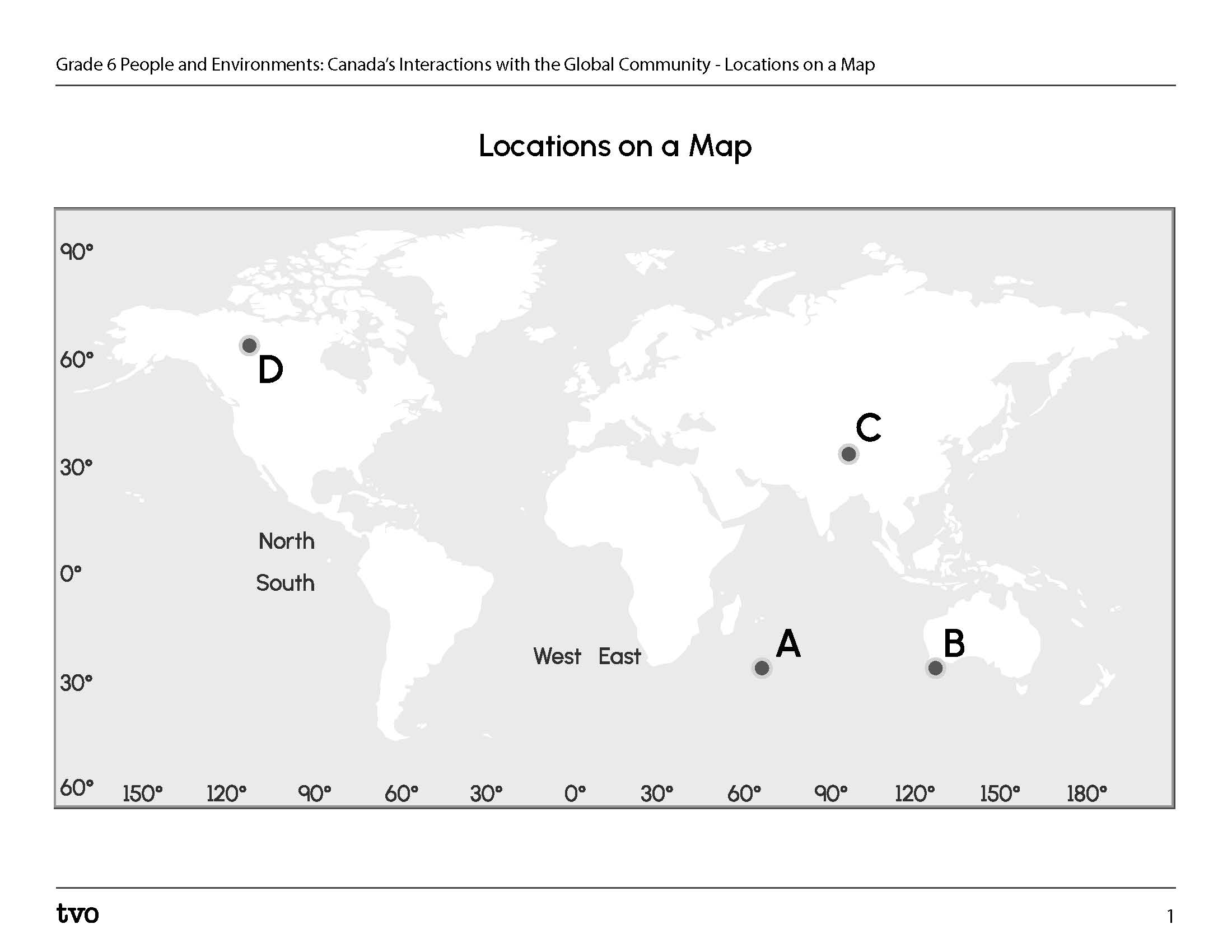
Press ‘Answers’ to access the Locations on a Map answers.
Notice that you always give the latitude first, followed by the longitude.
- Point A: (30°S, 60°E)
- Point B: (30°S, 120 °E)
- Point C: (30° N, 90° E)
- Point D: (60° N, 120° W)
Consolidation
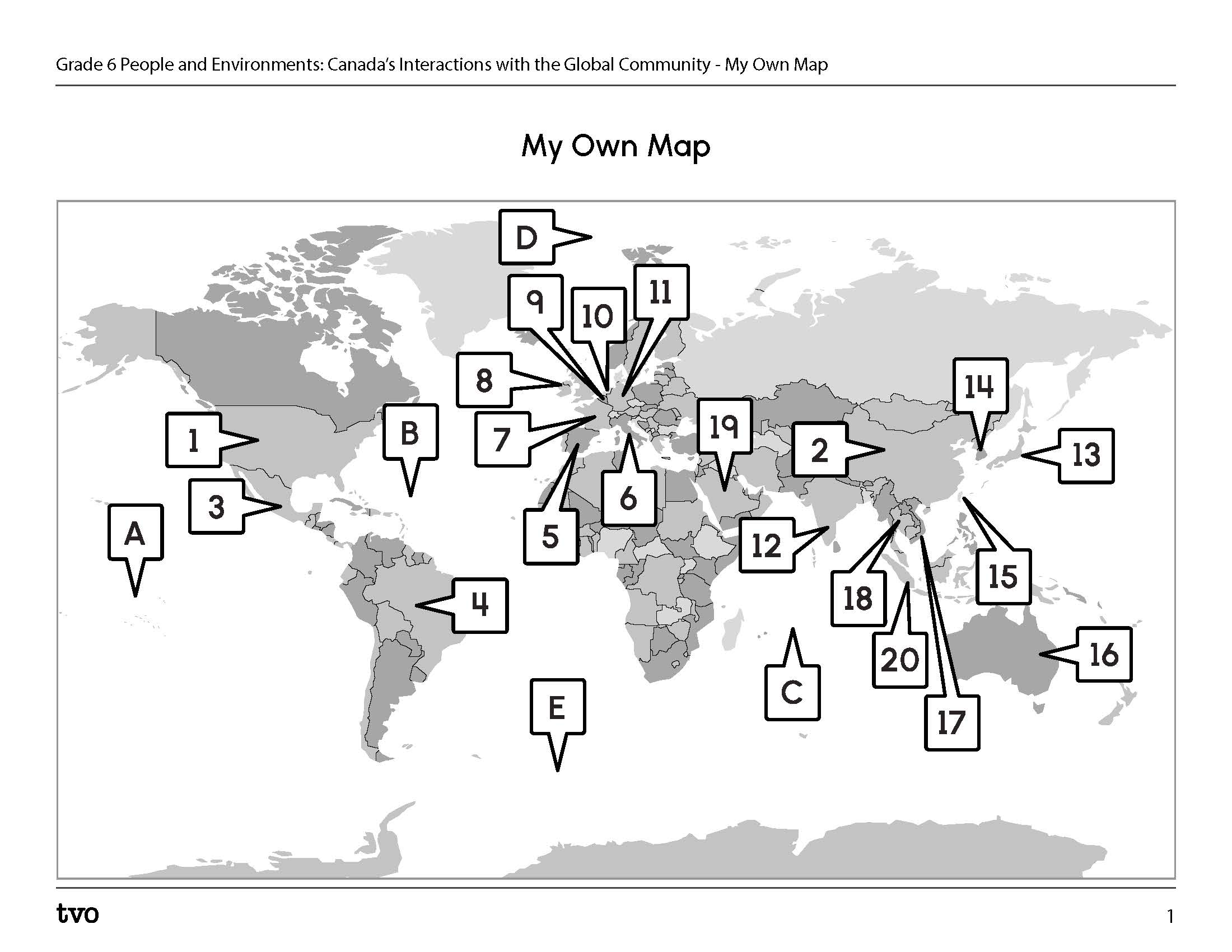
Let’s create our own maps

In this activity, you will create your map. You will select 10 of 20 countries that are provided in the following list. You will locate the countries that you have chosen on the map and write their names. You will also identify 8 capital cities for 8 countries from the 10 that you have chosen.
Complete the following steps in order to create your own map.
- Locate the country Canada.
- Select 10 countries from the following list. Make sure you have at least five countries from
the Northern Hemisphere and five countries from the Southern Hemisphere.
- United States, China, Mexico, Japan, United Kingdom, Germany, South Korea, Italy, France, India, Netherlands, Belgium, Taiwan, Indonesia, Vietnam, Brazil, Saudi Arabia, Spain, Thailand, Australia.
- Create a map legend that includes the country name and the method you selected to identify each country on the map. You may choose to identify the country on the map using a symbol, a dot, or any other method of your choice. You can also create a detailed written or audio description of the location of each of your selected countries.
- Create a title for your map.
- Label the five oceans on the map or list the five oceans in your description and identify their location relative to other countries.
- Find the latitude and longitude of eight of the capital cities in the countries you have selected and record your findings in the chart provided, on the computer, on paper, or in an audio recording.
Record your thoughts for this activity by completing the My Own Map in your notebook or using the following fillable and printable document.
Reflection
As you read through these descriptions, which sentence best describes how you are feeling about your understanding of this learning activity? Press the button that is beside this sentence.
I feel...
Now, record your ideas using a voice recorder, speech-to-text, or writing tool.